
Review: OsmAnd - the Swiss Army knife of offline mapping apps
Update 12th October 2024: Due to popular demand, another tranche of free Pro licences available - see the link below

What we likeD
Super-detailed offline maps for entire world & no per-map payments
Super-customisable maps, screens and tools
Trip-recording, Route-planning & Navigation - all offline
Great phone battery conservation
Ability to add missing map features to the OpenStreetMap community
Available for both Android and iPhone
What we didn’t
Is too much customisability possible? It can mean the User Interface can be hard to get your head around at times
The Verdict
THE SHORT READ…
Arguably one of the most powerful off-line global mapping apps you can get - if you’ve got no mobile signal by choice or circumstance then OsmAnd is brilliant tool to figure out where you are, where you are going, how to get between the two, recording your route as you go, going easy on your battery, and much, much more.
It’s not without it’s quirks - you can end up scratching your head to find some bit of the customisation you know you’ve seen somewhere before in the menus, and the large amount of map detail offered can mean that some phones might struggle to draw new areas of the map instantaneously - but despite these, OsmAnd is a highly recommended addition to your mountain-safety App quiver.
If you like what you read here, and are quick, we have some free one-year OsmAnd Pro subscriptions (i.e. the primo, paid-for option) to give away here - grab ‘em while they are hot! See the link below:

Examples of different map styles you can choose…
THE LONG READ …
The level of map detail and features OsmAnd offers, as well as how crazy customisable it is, is kind of staggering.
What does it’s name mean? Well, the “Osm…” bit refers to OpenStreetMap, that vast open-source, community-driven mapping project that is the main source of it’s map data, while the “…And” bit doesn’t actually stand for “Android” but apparently for “Automated Navigation Directions” - and is availalable to you iPhone types as well.
OsmAnd makes an excellent choice as your default daily workhorse offline mapping application - though as with any tool, you might still want to employ other mapping apps at times, for the different things they excel at – like Fatmap for it’s 3D satellite maps, library of public routes, and brilliant colour-coding of aspect, avalanche-risk gradients, etc.
So let’s dig into some specifics – but be warned, we’ll only scratch the surface here of what OsmAnd can do – if it were a swiss-army knife, it’d be too big for your pocket, you’d probably need to carry it in a trailer or something.

Getting started
First, downloaded some maps! Available for the entire globe, by Country and Region. For England say, there’s an all-England map, or just get the East Midlands, Greater London, or South West England, etc. When going somewhere new, I download the following for that country or region: The Standard map, plus the Contour lines, plus the Terrain map (which gives you the hill-shading - either in grey, or coloured by slope-angle).
Next, customise your map display and tools! Only if you want to personalise the map and screen appearance, of course. And you will! Add widgets for showing current altitude and speed, put your map-orientation icon where you prefer it, add a route-recording widget (start, stop, pause etc), and another widget for turning the “Radius Ruler” tool on and off (basically a compass and super-duper map scale overlay), and turn on the “Distance by tap” feature (brilliantly simple, it draws a line between your current location, or two points you tap at the same time on the screen, and tells you the distance between them).
That’ll get you going.

Downloaded regions (green)

Contour lines and hill-shading

“Radius ruler” & compass turned-on

Distance between two points
Show me the detail! The power of OpenStreetMap…
The underlying open-source, collaborative OpenStreetmap project maps is excellent - check out the three images here - the first is OpenStreetMap as used in OsmAnd, then Googlemap, and then the UK’s own national Ordnance Survey map. You can see that OpenStreetMap actually compares super-well for detail at this zoom level (and you can also tweak it to show more or less detail at different zoom levels).

OsmAnd (via OpenStreetMap)

Googlemap

Ordnance Survey (UK)
Map styles - OsmAnd can present the same map data you downloaded in multiple different visual ‘styles’, each of which is designed to visually emphasis different things, to make for easier reading while doing those things, for example there are ones emphasing hiking trails, or emphasising cycling routes, or emphasising driving roads.
Map drawing Performance - Depending on what options you have turned on, you can end up with a lot of data layers that need to be drawn, so when turning the app on initially, or moving the screen to a new map area that it has to now draw, it can take a couple of seconds to complete all that rendering. Most noticeable in cities, where there is a ton of detail, and for older phones. It is a tad slower in this regard than some other apps, but then, the amount of data can be higher too.
Add missing features to the map - One joy of the OsmAnd / OpenStreetMap combo is that you can contribute your own edits to the maps, for everyone using OpenStreetMap to see. Missing buildings? A missing trail you’ve just walked and GPX’d? Watch out, you can get hooked on this – add the missing things either via the OpenStreetMap website, or via an OsmAnd app plug-in, then just wait a few days maybe for it to appear in the next map update. Literally tonnes of people around the world are contributing new map detail and points of interest as we speak - there are even dedicated stats sites that can tell you stuff like “516 contributors made 142,284 map edits in 84 countries in the last 60 min”. Very cool.
And on top of all this, you also have a ton of control over exactly what details and objects to show on the maps, what language you want labels in, what types of local or internationally documented trails to include (horse-riding? Mountain biking? Cycling paths?), and so much more.
Trip recording
Super simple, it draws your route on the map as you go. You can then save your routes to the phone and/or to cloud locations like google drive - from where you can upload to Strava (say).
Analyse your speed, time, altitude, slope angles on the route, in nice charts.
As you are recording, widgets on your map screen can show stats like total distance, altitude gained or lost, duration etc of your track so far.
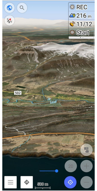
Your route trail can be colour-coded by slope angle, your speed, altitude, or just solid lines in a width you can select.

Route or track with colour-coded slope angle (3D)

And the same in 2D

Analysing your route

How high?
Route planning
It took me a while to even try this, thinking that planning a route on a tiny device like a phone would lead to a lot of squinting and cursing. But no, it’s super easy! OsmAnd can snap nicely onto trails and roads between points you pick, or just have it draw straight lines. Save the route, then follow it on-screen. OsmAnd also provide a website where you can draw new routes, edit existing ones and sync them with the app.
Offline Navigation
When I compare OsmAnd’s suggested routes (offline remember!) with what google maps (online) chooses, they are often identical.
Battery conservation
Really good. With my three-year old Google Pixel 5, in flight mode, OsmAnd has let me squeeze 12+ hours of continuous route-recording out of the phone - and that’s with me interacting loads with the map - zooming, rotating, searching for water fountains, ATMs, cafes etc, having also snapped loads of photos, and occasionally taken the phone out of flight-mode to contact the outside world.
You want more? How about…
Wikipedia articles - Offline enlightenment about points of interest in the region or country.
Google Streetview style imagery - Pull images from Mapillary - and contribute if you like by adding your own.
Weather forecasts - See the rain, wind and what headwinds you are in for.

Weather!

Wikipedia! (offline access)

Mapillary - like Google Streetview
And you get really good support too…
You mean real people to communicate with? Yep - OsmAnd’s support crew are brilliant - Ask questions by email, or subscribe to their Telegram channel, and report bugs or request new-features by signing up to their associated Github (issue-tracking) site. I recently logged a bug I’d spotted and the team fixed it in an major app update less than three weeks later.
Cost – take your pick from:
OsmAnd Free - the app is “OsmAnd” - It’s limited to just 7 map downloads at any one time, but that’s easy to manage. The biggest downside is no contour-lines or terrain-shading though. And no 3D map views or offline Wikipedia. But it’s a good entry point to try out a lot of the features for no cost.
OsmAnd+ A one-off lifetime payment of €29.99 – Actually a different App, called “OsmAnd+” - Unlimited map downloads, regular map detail updating, contour-lines, terrain-shading and Wikipedia downloads. No 3D but you get 95% of the Pro features here. Slightly confusingly, if you installed the free version of the app, you can upgrade from there to get the same features as the OsmAnd+ app, which then is called “Maps+” … but the same features and same price (though that way there is actually an additional €9.99 per year option too).
OsmAnd Pro 2.99€ / month or 29.99€ per year – from either the OsmAnd or OsmAnd+ apps - Now you get 3D maps, a few extra customisation options, hourly map refreshes (for all the data added constantly by punters and professional organisations globally), plus access to some cloud storage features.
To be honest, unless you are going to totally geek-out on this app (which is a risk, I warn you) and can do without 3D (quite possible, if you also use complementary apps like Fatmap, say), then the OsmAnd+/Maps+ one-off lifetime payment option is pretty outstanding value.
But first, check if any of our free one-year OsmAnd Pro subscription codes are still available!
SUMMARY…
A superb offline mapping tool.
When you are setting it all up initially, you might get a bit lost in the menus, but you’ll get there. And OsmAnd support are super helpful. And there is good online documentation too. Once set up as you like it, it’s a doddle to use. Due to the amount of data it makes available, initial map drawing can have fractional more delay compared to some other apps, but you get a lot of detail. It does all the other basics super well - route planning, route recording, navigation, managing your battery etc, and the customisation and range of other tools you can bolt on is stupendous.
Have fun!